
Guide
Google Maps to video app: turn a directions link into an animation
25 August 2026
Paste a Google Maps or Apple Maps directions link into Wander and export an animated map video. The clip on this page is the Garden Route, exported from a phone.
People look for a Google Maps to video app when the trip already lives in Maps and they want a clip, not another slideshow. The usual attempt is screen-recording the Maps app. It looks like a screen recording: thumbs, UI chrome, jumpy zoom, no vehicle.
Wander is the other path. You paste a Google Maps directions link (Apple Maps too), it builds an editable route, you pick a map style and a vehicle, and you export an MP4. This page is that flow, plus what a Maps link can and cannot become.
What Google Maps will not give you
Google Maps does not export a cinematic video of your directions. There is no “Share as video” button. People work around that in three ways: screen-record Maps or Google Earth (fast, ugly, hard to crop), draw the line in After Effects or a browser (powerful, slow, not a phone job), or use a route animation app that takes the same link you already copied.
Wander is the third option. It runs on Android. The output is 9:16, 1:1, or 16:9, at 1080p on Free or 4K on Pro. iPhone is coming soon.
Copy a directions link, not a place pin
In Google Maps, build the route the way you would for a friend: start, stops, end. Then share the directions and copy the link. A directions URL has the path in it. A place URL is one pin. Wander needs the path. If you paste a single restaurant, you get a point, not a trip.
Apple Maps share links work the same way. If you planned the drive in Apple Maps, you do not have to rebuild it in Google first. GPX is the other import when the “route” is a recorded track rather than a driving directions line. That is the road trip case.
Paste, then edit
Open Wander, create a project, paste. Wander parses the stops and lays them on the map. You can still drag or reorder stops, delete a waypoint Maps added as a petrol station, switch a leg from road to flight if the trip is a plane, or add a stop Maps missed.
The paste is the start of an editor, not a one-shot render. That is the difference from a screen recording. You can fix the route before anyone sees the video.
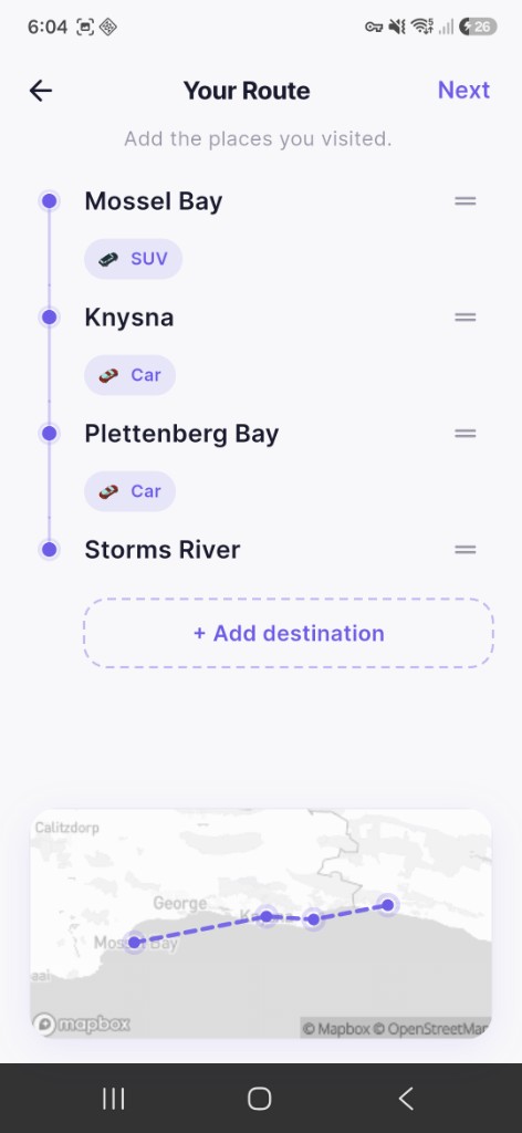
You can tap every stop by hand instead. Paste is faster when the trip already lives in a Google Maps share, a friend sent the itinerary as a link, or you do not want to retype twelve names. Hand-tapping is better when Maps over-simplified a scenic road, or when you want a boat line that Maps would force onto ferries you do not care about. Mix both: paste, then edit.
Style it so it does not look like Google Maps
A Google Maps screenshot already exists. The point of the video is that it does not look like the app you pasted from.
Wander has 18 styles on Free. Satellite for a coast, island chain, or mountain road. Topographic when the terrain is the story. Golden Hour or Film when the clip has to sit next to travel photos. Midnight Drive for a night city run. Then pick a vehicle that matches the mode: car, boat, plane, train, or bicycle on Free. Pro adds campervan, bus, SUV, and motorcycle.
If the Maps link is a flight, use Flight Mode for the arc. A driving path across an ocean is the wrong geometry.
Export for the app you will post to
| Where it goes | Aspect | Notes |
|---|---|---|
| TikTok, Reels, Shorts | 9:16 | See how to make a route animation for TikTok |
| Instagram feed | 1:1 | Square crop; keep labels short |
| YouTube | 16:9 | Landscape; longer duration is fine |
Free is 1080p with a watermark. Pro is 4K with no watermark. Five projects and 20 stops on Free; unlimited on Pro. Pro is £4.99/month or £24.99/year. Export writes an MP4 to your library. From there it is a normal share. Wander does not post for you.
What the link does not become
Wander will not stream live traffic or Street View into the video. It will not keep Google’s turn-by-turn voice or the ETA. It will not pull photos from the trip. The video is the map and the vehicle. Photos are a separate edit if you want them.
If you need turn-by-turn as the video, you want a screen recording of navigation, not Wander. If you need a cinematic path, you want Wander.
The clip on this page
The video at the top is the Garden Route in South Africa: a car on a topographic map, exported 9:16 from a phone. That is the same class of trip people paste from Google Maps, a coastal drive with a few headline stops, not a logistics trace.
Use satellite if you want water and headlands to dominate. Use topographic if you want the road to read as a line through terrain. Either is a video, and neither is a Maps screen recording.
Export a video from a route.
Free on Google Play. iPhone coming soon.